Saturday, June 30, 2012

Mazingira Kilimanjaro

Habari ya zamani,
RAIS KIKWETE AELEZEA ATHARI ZA MAZINGIRA
http://www.kilimanjaro.go.tz/kurasa/habari_moto/hm3/index1.php
Rais wa Jamhuri ya Muungano wa Tanzania, Mheshimiwa Dokta Jakaya Mrisho Kikwete ametoa mifano saba ambayo ni ishara za athari mbaya zinazotokana na uharibifu mkubwa wa mazingira uliosababishwa na shughuli za binadamu.Akihutubia mamia ya wananchi kwenye siku ya Kilele cha Maadhimisho ya Siku ya Mazingira Duniani ambayo kitaifa iliadhimishwa katika Uwanja wa Mashujaa katika Manispaa ya Moshi. Rais Kikwete amewataka wananchi kuchukua hatua thabiti ili kupambana na uharibifu wa mazingira.
PICHANI : Rais Kikwete akikata utepe kuzindua mradi wa upandaji wa miti wa Kanisa la KKKT Dayosisi ya Kaskazini ( Picha na Shaban Pazi wa Ofisi ya Mkuu wa Mkoa)
Akielezea chimbuko la uharibifu wa mazingira Rais Kikwete amesema “Sisi Wanadamu tusipokuwa makini na kuchukua hatua thabiti za kutunza na kuhifadhi mazingira, uhai na ustawi wetu utakuwa mashakani ” alisema Mheshimiwa Kikwete na kusisitiza kuwa aihitaji kuwa mwanazuoni kuujua ukweli huu.
Akieleza mifano saba kati ya dalili nyingi za athari zilizotokana na uharibifu mkubwa wa mazingira ,Rais Kikwete ameanza na mabadiliko ya majira ya mwaka ambayo yamepelekea kukosekana kwa mvua za kutosha ambazo hunyesha bila ya kufuata misimu sahihi na hatimaye kusababisha ukosefu wa chakula kwani mavuno hukosekana katika kila msimu wa kilimo. Kukosekana kwa huduma muhimu zikewemo maji na umeme nayo ni moja ya majanga ambayo yameelezwa kusababishwa na ukame wa muda mrefu unaopelekea kukauka kwa vyanzo vya maji na mabwawa ambavyo ni vyanzo vya uzalishaji wa nishati muhimu ya umeme.Upungufu wa theluji katika maeneo ya ncha za Kaskazini na Ncha ya Kusini (South Pole na North Pole) za duniani ni athari ya pili kati ya athari zilizotokana na uharibifu mkubwa wa mazingira. Mheshimiwa kikwete amesma milima mikubwa yenye barafu katika maeneo haya inayeyuka. Aidha Mheshimiwa Kikwete ameeleza kuwa hata theluji iliyo kwenye vilele vya milima mikubwa duniani inayeyuka. Akitoa mifano ya milima ya Evarist , Milima ya Ulaya na hata mlima Kilimanjaro.
Kuyeyuka kwa theluji hiyo kumepelekea madhara mbalimbali katika uso wa dunia likewemo tatizo la kuzama kwa baadhi ya visiwa na kuto mfano wa kisiwa cha Mazimwi katika aneo la Pangani Mkoani Tanga kilikuwa
kikitumiwa na wanyama aina ya kasa kutaga katika eneo hilo kwa sasa kimeshazama. Mbali na hilo Mheshimiwa Kikwete amesema mji wa Pangani upo hatarini kuzama baharini na kusema kwa sasa serikali ina kazi ya kujenga ukuta ili kuunusuru mji huo ili usizame majini.Ongezeko la magonjwa nayo ni moja ya athari zilizotokana na uharibifu wa mazingira uliokithiri. Akitoa mfano wa ugonjwa malaria Rais Kikwete amesema hapo zamani ugonjwa wa malaria haukuwepo katika baadhi ya maeneo hususan yale maeneo ya miinuko ambayo hali ya hewa ilikuwa ni baridi katika majira yote ya mwaka lakini kwa sasa watu wa maeneo hayo wanasumbuliwa na ugonjwa huo kutokana na kuongezeka kwa joto Athari nyingine ni kasi kubwa ya kupungua kwa misitu hali ambayo inafanya kuongezeka kwa jangwa na kupelekea ukame kwa muda mrefu kwani mvua, mito, vijito na chemchem zimetoweka. Athari ya mwisho aliyoielezea Mhesimiwa Kikwete ni kupungua kwa ubora wa ardhi ambao hupelekea mmomonyoko wa udongo, kupungua kwa mazao ya shambani na kukosekana kwa malisho ya mifugo . Mheshimiwa Kikwete alitoa changamoto ya kupambana na athari hizo za mazingira kwa kuwataka wananchi kuchukua hatua za dhati katika kupunguza kasi ya kuharibu mazingira, kuendeleza juhudi za kujenga upya pale walipoharibu na kulinda pale palipo salama kwani chanzo kikuu cha kuharibika kwa mazingira ni jitihada za wanadamu katika kutafuta rizki na kujiletea maendeleo. Kwa mujibu wa Rais Kikwete wananchi walishindwa kuweka uwiano mzuri kati ya kile wanachochukua kutoka kwenye ardhi na kile wanachobakisha au kurudisha kwenye ardi hiyo . Aidha Mheshimiwa Kikwete ametoa pongezi kwa baadhi ya Serikali za Mitaa ambazo zimeunda kamati za mazingira zinazoratibu shughuli za usafi na utunzaji wa mazingira. Napenda kutumia nafasi hii kuzipongeza baadhi ya Serikali za Mitaa ambazo zimeunda Kamati za Mazingira ili kuratibu shughuli za kuhifadhi mazingira katika maeneo yao. Napenda kutoa mwito kwa Serikali za Mitaa ambazo bado hazijaunda Kamati hizo, wafanye hivyo mapema iwezekanavyo. Tayari nimewaagiza Wakuu wa Mikoa na Wilaya zote nchini kusimamia kwa makini Sheria na Kanuni za Hifadhi ya Mazingira katika maeneo yao. Natumaini hili litafanyika. Alisema Rais Kikwete. Rais Kikwete alitumia sherehe hizo kuzindua Kampeni ya Taifa ya Usafi na Ujenzi wa Vyoo Bora ambao unaendeshwa kwa ushirikiano baina ya Serikali, Wananchi na Washirika wa Maendeleo wa Tanzania ikiwemo Benki ya Dunia na Shirika la Umoja wa Mataifa la Mfuko wa Watoto (UNICEF). Kabla ya kufika katika uwanja wa Mashujaa Rais Kikwete alipanda Mzeituni kama ishara ya kuzindua Mpango wa Upandaji Miti wa Kanisa la Kiinjili la Kilutheri (KKKT), Dayosisi ya Kaskazini ambayo ina mpango endelevu wa kupanda miti kwa kuweka utaratibu wa kila mtoto atakayepokea kipaimara atatakikiwa kupanda miti kumi na kuitunza. .

Wednesday, June 27, 2012

Mama Lynn's Story - Light in Africa - Tanzania

Same districts Kilimanjaro


Pic from Hai Kilimanajro


    photo

    Mount Kilimanjaro's Twin Peaks

    Sun is beginning to go down in Amboseli National Park as the twin peaks of Kilimanjaro are revealed. Photo taken by Christopher M. Dawson with a Nikon D60 on 5/14/09 in Kenya

    Comments and faves

    Kilimanjaro life

    image from http://kilimanjarocalling.blogspot.se/


    Kilimanjaro Region

    The Kilimanjaro Region is administratively divided into seven districts Hai According to the 2002 Tanzania National Census, the population of the Hai District was 259,958. The Hai District is administratively divided into 14 wards: Hai District Hai Mjini Machame Kaskazini (North) Machame Kusini (South) Machame Magharibi (West) Machame Mashariki (East) Machame Uroki Masama Kusini (South) Masama Magharibi (West) Masama Mashariki (East) Masama Rundugai Siha Kaskazini (North) Siha Kati (Central) Siha Magharibi (West) Siha Mashariki (East) [edit] Rombo The Rombo Districts contain a large portion of Mount Kilimanjaro. According to the 2002 Tanzania National Census, the population of the Rombo District was 246,479. The Rombo District is administratively divided into 20 wards: Rombo District Katangara Mrere Kelamfua Mokala Keni Aleni Keni Mengeni Kirongo Samanga Kirwa Keni Kitirima Kingachi Mahida Holili Makiidi Mamsera Mengwe Manda Motamburu Kitendeni Mrao Keryo Nanjara Reha mahida nguduni Olele Shimbi Tarakea Motamburu Ubetu Kahe Ushiri Ikuini Mahida mahango [edit] Moshi Urban According to the 2002 Tanzania National Census, the population of the Moshi Urban District is 144,336. The Moshi Urban District is administratively divided into 21 wards: Moshi Urban District Bondeni Kaloleni Karanga (English meaning: "peanuts/groundnuts") Kiborloni (From the English words "Keep on rolling") Kilimanjaro Kiusa Korongoni Longuo Majengo (English meaning: "buildings") Mawenzi (Name given to one of the peaks of Mt. Kilimanjaro) Mji Mpya (English meaning: "new Town") Msaranga Njoro (English meaning "water" from Maasai people) Rau Pasua (Literally meaning "break") Miembeni (Literally meaning "where there are mangoes") Ngangamfumuni Ng'ambo Bombambuzi Shirimatunda Soweto (Abbreviation for "South West Town") [edit] Moshi Rural According to the 2002 Tanzania National Census, the population of the Moshi Urban District is 402,431. The Moshi Rural District is administratively divided into 31 wards: Moshi Rural District Arusha Chini Kahe Kahe Mashariki (East) Kibosho Kati (Central) Kibosho Magharibi (West) Kibosho Mashariki (East) Kilema Kaskazini (North) Kilema Kati (Central) Kilema Kusini (South) Kimochi Kindi Kirima Kirua Vunjo Kusini (South) Kirua Vunjo Magharibi (West) Kirua Vunjo Mashariki (East) Makuyuni Mabogini Mamba Kaskazini (North) Mamba Kusini Marangu Magharibi (West) Marangu Mashariki (East) Mbokomu Mwika Kaskazini (North) Mwika Kusini (South) Okoani Kibosho Old Moshi East Old Moshi West Uru Kaskazini (North) Uru Mashariki (East) Uru Shimbwe Uru South Mawela [edit] Mwanga According to the 2002 Tanzania National Census, the population of the Mwanga District was 115,620. The Mwanga District is administratively divided into 16 wards: Mwanga District Chomvu Jipe Kifula Kighare Kileo Kilomeni Kirongwe Kirya Kwakoa Lang'ata Lembeni Msangeni Mwanga Mwaniko Ngujini Shigatini [edit] Same According to the 2002 Tanzania National Census, the population of the Same District was 212,235. The Same District is administratively divided into 25 wards: Same district Bombo Bendera Bwambo Chome Hedaru Kihurio Kirangare Kisiwani (English meaning: on the island) Makanya Maore Mhezi Mpinji Mshewa Msindo Mtii Mwembe (English meaning: mango tree) Myamba Ndungu Njoro Ruvu Same Mjini Suji (Suji, Kilimanjaro) Vudee Vuje Vunta

    Kilimanjaro Marathon

    http://www.kilimanjaromarathon.com/index.php?q=con,1,Home Page

    AMANI CHILDRENS HOME

     located in Moshi Kilimanjaro

    Amani Children's Home
    Rescuing Children. Restoring Hope. Transforming Lives.
    Agnes
    Babu

    How about the future of city plan in Moshi?


    Moshi

    From Wikipedia, the free encyclopedia
    Jump to: navigation, search
    Moshi
    Municipality
    Moshi panorama with Mt Kilimanjaro in the background
    Moshi Map
    Moshi is located in Tanzania
    Moshi
    Location of Moshi
    Coordinates: 3°20′05.58″S 37°20′25.37″E / 3.3348833°S 37.3403806°E / -3.3348833; 37.3403806Coordinates: 3°20′05.58″S 37°20′25.37″E / 3.3348833°S 37.3403806°E / -3.3348833; 37.3403806
    CountryTanzania
    Wards
    Government
    Moshi Municipal DirectorBernadette Kinabo
    Moshi Municipal MayorJaphery R. Michael
    Area[1]
    • Total59 km2 (23 sq mi)
    Highest elevation950 m (3,120 ft)
    Lowest elevation700 m (2,300 ft)
    Population (2002)[2]
    • Total144,739
    • Density2,453/km2 (6,350/sq mi)
    Time zoneEast Africa Time (UTC+03)
    Area code(s)+255
    WebsiteMoshi Municipal Council
    From top: Kilimanjaro Mountain, Moshi Hotel (formerly the Livingstone Hotel), A23 Arusha-Himo road, Clock Tower
    Moshi is a Tanzanian municipality[3] with a population of 144,739 according to the 2002 census[2] and an estimated 2011 population of 206,728.[4] The municipality is in the Kilimanjaro Region and is situated on the lower slopes of Mt Kilimanjaro, a dormant volcano that is the highest mountain in Africa. The municipality covers about 59 km2 and is the smallest municipality in Tanzania by area.[4]
    Many people from the Chagga and Pare ethnic groups live in Moshi, which lies on the A23 ArushaHimo east–west road connecting Arusha and Voi, Kenya. Just to the east of Moshi is the intersection with the B1 north–south road eventually connecting with Tanga and Dar es Salaam. Moshi is often considered the cleanest town in Tanzania.[1]

    Contents

    [hide]

    [edit] History and administration

    By force, Germany established a military camp in Moshi in August 1893.[5] Moshi attained the status of a town in 1956. In 1988, it became a municipality under Tanzanian law and is planned to become a city by 2016.[4]
    Moshi is divided administratively into 21 wards and then subdivided into 60 hamlets.[4]
    The municipal budget of Moshi in fiscal year 2010/2011 was estimated to be 18.2 billion Tanzanian shillings or US$11.5 million at an exchange rate of 1,587 shillings per dollar.[4]

    [edit] Education

    Like all of Tanzania, Moshi has universal primary education. According to the Tanzania Demographic and Health Survey 2010, the Kilimanjaro Region, which includes Moshi, had the second highest female literacy rate and the third highest male literacy rate among Tanzania's then-existing 26 regions.[6] According to the Tanzania Poverty and Human Development Report 2005, the Moshi urban district had the highest literacy rate for persons over 15 years of age when compared to any of the 128 other districts in Tanzania.[7]
    Moshi hosts a number of higher education facilities. Those include the Kilimanjaro Christian Medical College (KCMCo), the Stefano Moshi Memorial University College (SMMUCo), the Mwenge University College of Education (MUCE), the Moshi University College of Co-operative and Business Studies (MUCCoBS), the College of African Wildlife Management (CAWM), and the Kilimanjaro School of Pharmacy (KSP).
    • KCMCo is a campus of Tumaini University. It was started in 1997 and offers a number of medical courses. The college is located within the Kilimanjaro Christian Medical Centre complex, about 6 km from Moshi.
    • SMMUCo is also a campus of Tumaini University. It was developed from the Masoka Management Training Institute and the Mwika Lutheran Bible College. It belongs to the Evangelical Lutheran Church in Tanzania - Northern Diocese, and it is a multi-campus university college. Currently, SMMUCo has campuses in Masoka, Mwika and Moshi, with future campuses planned for Machame, Siha, and Karatu.
    • MUCE is a constituent college of the Saint Augustine University of Tanzania. It offers a model of professional excellence, as a center for training teachers and students to become clear thinkers while providing a holistic approach to learning and teaching through promotion of flexible teacher training programmes focused on appropriate methodologies. MUCE is located 10 km north of Moshi.
    • Since May 2004, MUCCoBS has been a constituent college of the Sokoine University of Agriculture. Formerly known as the Ushirika College, it is the oldest training institution in Tanzania and is located along Sokoine Road in Moshi. MUCCoBS has accumulated 43 years' experience in the fields of co-operative accounting, co-operative management and rural development has of recently turned into other expertise in accounting, management, marketing, auditing and cooperative development employed in different institutions within and outside Tanzania. MUCCoBS grew from a college enrolling only 150 students, conducting tailored courses, to a university college with a capacity of 1500 students.
    • CAWM is commonly known as Mweka College. It was established in 1963 following the Arusha Manifesto (1961) as a pioneer institution for the training of African wildlife managers. Since this time, the College has been a leader in providing quality wildlife management training in Africa, and has trained over 4,000 wildlife managers from 28 African countries and 18 non-African countries. The majority of the CAWM's students come from the SADC region, although the College opens its doors to all students with an interest in African Wildlife Management.
    • KSP is owned by the Saint Luke Foundation, a registered trust founded to provide broad spectrum services to an African population that faces serious deficiencies in pharmaceutical and health systems. KSP is currently the only pharmacy school providing competence based training for different levels of pharmaceuticals cadres to a diploma level.
    Moshi also has several secondary schools. The government schools are Mawenzi Secondary School, Moshi Technical School, Moshi Secondary School, and J. K. Nyerere Secondary School. The private schools are Majengo Secondary School, Northern Highland Secondary School, International School Moshi, and Kibo Secondary School. In addition, each ward of Moshi has a community-established secondary school, such as Rau Secondary School and Kiboriloni Secondary School.
    • Mawenzi Secondary School started as the Indian School of Moshi in 1956. It is now a thriving school of 1,100 pupils. All A-Level students are female boarders and come from all over Tanzania. The school specialises at A-Level in Kiswahili, geography, history, and English. The school operates a double shift system for junior pupils (Form 1–4). All subjects are taught in English, apart from Kiswahili and French. Mawenzi School has had a link with Buckie High School in Scotland since 1987. Pupils and teachers have travelled between Tanzania and Scotland many times.
    • International School Moshi (ISM) was established in 1969 to serve the needs of the expatriate and local communities. ISM has about 400 students from nearly 40 different nationalities on two campuses in Moshi and Arusha.[8] The Moshi campus has about 190 students, including 90 boarders, from 25 nationalities and offers a full range of courses from early childhood to the International Baccalaureate Diploma.[9] ISM has been an International Baccalaureate World School since 1977.[10] ISM is one of only two world schools in Tanzania to offer the primary years, middle years, and diploma programmes.[11]
    There are also various English academic schools with pre-primary, primary, and secondary education, such as the Eden Garden schools.
    There are a number of non-governmental organizations in Moshi assisting with education. One of them is Give a Heart to Africa,[12] which offers free education to adult women and assists several of them with starting their own businesses.

    [edit] Medical care

    The main private referral hospital in the area is the Kilimanjaro Christian Medical Centre (KCMC). This huge complex has more than 450 beds and serves a population of over 11 million individuals. The Good Samaritan Foundation of Tanzania founded KCMC in March 1971.[13]
    Next to KCMC is the Kilimanjaro Centre for Community Ophthalmology (KCCO), which was founded in 2001 and is co-directed by Dr. Paul Courtright and Dr. Susan Lewallen. A new three-story building for KCCO was finished in 2007, funded by several individuals and non-governmental organizations.[14] The KCCO is "dedicated to the elimination of avoidable blindness through programmes, training, and research focusing on the delivery of sustainable and replicable community ophthalmology services".[15] The KCCO has an "official memorandum of understanding ... with the Department of Ophthalmology and Kilimanjaro Christian Medical College under which the KCCO assumes or shares responsibility (subject to specific funding grants) for many teaching activities, running workshops and seminars, supervising the ... [Ophthalmic Resource Centre for Eastern Africa], serving in an advisory capacity for planning Eye Department services, conducting epidemiologic and clinical research in prevention or treatment of vision loss or related fields, and serves on committees".[16]
    Moshi also hosts the Kilimanjaro Clinical Research Institute (KCRI), which is the research arm of KCMC. KCRI evolved from the Kilimanjaro Clinical Research Centre (KCRC) in 2009. KCRC was established in 2006 with the support of the Dutch government through the Netherlands-African partnership for Capacity development and Clinical interventions Against Poverty-related disease (NACCAP).[17][18]
    The primary public hospital in Moshi is the Mawenzi Regional Hospital, which started sometime before 1920 as a small dispensary for German soldiers and became a hospital in 1956. The hospital has about 300 beds but is severely underfunded. In late 2010, its surgical services were suspended indefinitely by the Government and Private Hospitals Inspection Committee of the Tanzanian Ministry of Health and Social Welfare. The head of the committee, Dr. Pamella Sawa, said, "During our inspection, we inspected the theatre room of Mawenzi Hospital and found it very dirty, with no[t] enough ventilation, the situation which is dangerous not only to the patient but also to his/her attendant...."[19] The hospital includes a Care and Treatment Centre for people living with HIV/AIDS. The hospital's physical therapy department has a student learning program in cooperation with Norway, in which Norwegian physiotherapy students in their second and third years come as short term apprentices.

    [edit] Other institutions and establishments

    Moshi municipality has other institutions and establishments, such as the Small Industries Development Organization, the Kilimanjaro Industrial Development Trust, the Furniture Industry Training Institute, the Moshi Memorial Stadium, and a small airport.
    The main market in Moshi is known as Soko La Kati. Moshi also has a large, open-air market known as Kiboriloni. The market, which is loosely structured, has been for decades a regional hub for commodities such as clothing, merchandise, fresh food, and household items. It operates four days a week. Most of the operators are local residents.
    Moshi has scheduled airline connections to the rest of Tanzania and other countries through Kilimanjaro International Airport, which is operated by the Kilimanjaro Airport Development Company and located in Hai District along the Moshi-Arusha Highway. Several international and domestic airlines operate there, including KLM, Condor Flugdienst, RwandAir, Fly540, Ethiopian Airways, Kenya Airways, Precision Air Services,[20] and, beginning 25 July 2012, Qatar Airways.[21]

    [edit] Tourism

    Askari monument in Moshi
    Moshi is often overlooked as a tourist destination, with many visitors to northern Tanzania staying in Arusha instead.
    Moshi, however, hosts several cultural tourism programs operating on the lower slopes of nearby Mt Kilimanjaro. Moshi also serves as the base for many expeditions up the mountain, with climbers staying in nearby hotels and employing local residents as guides, porters, and cooks.
    To promote tourism in the municipality, the Kilimanjaro Marathon was established in 2002 and is now held annually at the end of February or beginning of March. The race is a member of the Association of International Marathons and Distance Races. In 2012, 232 persons finished the 42.2 km full marathon,[22] and 1,609 persons finished the 21.1 km half marathon.[23] The race also includes a 5 km fun run. Apart from promoting tourism, the race promotes the sport in Tanzania and has the official backing of the Tanzania Tourist Board, Athletics Tanzania, and the International Association of Athletics Federations.

    [edit] Industry

    There are also a number of manufacturing industries including TPC Ltd (sugar cane and sugar), Bonite Bottlers (carbonated drinks), Serengeti Breweries (beer), Tanzania Breweries Maltings (malt for breweries), Interchem Pharmaceuticals, Kibo match, African Mosfly Industries Ltd, Union Service Stores (grain flour and animal feeds) and Imara (furniture). There are several metalworking workshops such as Simon Engineering, Press Forge and CFW Moshi. Moshi plays a host to a number of agri-industry activities that includes a number of green house farms for flowers and vegetables. Moreover Moshi, host a coffee factory (Milcafe LTD) that specialized in the blending and packaging of tea along with the curing, grinding, and packing of coffee.

    [edit] Agriculture

    Moshi's lower altitude and drier climate mean that the main crops grown on the higher slopes of Mt Kilimanjaro, coffee[24] and bananas,[citation needed] do not thrive there. The outskirts of Moshi are known for extensive farms of maize and beans, grown once per year during the long rainy season (known as "masika" in Kiswahili). In addition, the Tanganyika Planting Company operates a very large sugar cane plantation and company town 20 km. south of Moshi.[25]
    Roman Catholic missionaries introduced Arabica coffee cultivation to the Moshi region at the end of the 19th century.[26] The Kilimanjaro Native Co-operative Union was established in 1929[24] by the district commissioner, Charles Cecil Farquharson Dundas.[26] Its purpose was to enable Chagga coffee growers to compete on equal terms in world markets with European growers.[26] KNCU collects coffee from 96 village societies, representing over 150,000 small-scale farmers.[24] KNCU handles between 50 and 70 percent of the coffee grown in the area and trades over 5,250 tons of Arabica coffee, or about 11% of national production.[24]

    [edit] Climate

    Moshi has a tropical wet and dry climate. Its weather is dominated year round by monsoonal flow. The northeast monsoon prevails December through March and is accompanied by the highest temperatures of the year. The southeast monsoon prevails from June through September. Unique among the world's monsoons, both monsoons in Tanzania are divergent in the low levels, shallow (averaging only 2 km. in depth), and capped by inversion and dry, subsiding air. These factors result in light or insignificant rainfall year round except during the transitional periods between the monsoons.[27][28]
    Moshi's altitude keeps temperatures lower than surrounding cities, even without the maritime effects that a coastal city enjoys. Nighttime temperatures are relatively consistent throughout the year, averaging from 15 to 17 degrees Celsius. Moshi has noticeably warmer daytime temperatures from October through March, when average high temperatures exceed 30 degrees Celsius, and noticeably cooler daytime temperatures from May through August, when average high temperatures are 25 to 26 degrees Celsius.
    Moshi's wettest months are March through May, when around 71 percent of its annual precipitation falls.
    [hide]Climate data for Moshi
    MonthJanFebMarAprMayJunJulAugSepOctNovDecYear
    Average high °C (°F)33
    (91)
    33
    (91)
    32
    (90)
    29
    (84)
    26
    (79)
    25
    (77)
    25
    (77)
    26
    (79)
    28
    (82)
    31
    (88)
    31
    (88)
    32
    (90)
    29.3
    (84.7)
    Average low °C (°F)17
    (63)
    17
    (63)
    18
    (64)
    19
    (66)
    18
    (64)
    16
    (61)
    15
    (59)
    15
    (59)
    15
    (59)
    16
    (61)
    17
    (63)
    17
    (63)
    16.7
    (62.0)
    Precipitation cm (inches)3.0
    (1.18)
    5.0
    (1.97)
    11
    (4.3)
    35
    (13.8)
    23
    (9.1)
    3
    (1.2)
    2
    (0.8)
    1
    (0.4)
    1
    (0.4)
    2
    (0.8)
    6
    (2.4)
    5
    (2)
    97
    (38.19)
    Source: Weatherbase[29]

    [edit] Politics

    Moshi has been the base of opposition politics since the struggle for independence.
    The last Mangi Mkuu (Paramount Chief) of the Chagga, Thomas Lenana Marealle II, whose palace was located in Moshi, worked for the independence of Tanganyika when it was still a United Nations trust territory under British administration. In his speech to the United Nations Trusteeship Council on 17 June 1957, he said that Tanganyika could become self-governing within ten to fifteen years.[30] This speech occurred one day before Julius Nyerere addressed the same body.[31]
    Several presidential candidates and chairpersons of opposition parties, including Chadema (Party for Democracy and Progress), the National Convention for Construction and Reform - Mageuzi, the Tanzania Labour Party, and Demokrasia Makini, hail from the Kilimanjaro Region[citation needed] that has Moshi as its capital.
    In 2010, the unsuccessful Chadema presidential candidate, Willibrod Peter Slaa, received 55.6% of the popular vote in the Moshi Urban District compared to 43.5% for the nationwide winner, Jakaya Mrisho Kikwete of the Chama cha Mapinduzi party.[32]
    The Moshi Urban District parliamentary seat is one of the few seats in the country to be held continuously by an opposition political party since the first multiparty election of 1995.[citation needed] In 2010, the Chadema parliamentary candidate, Philemon Kiwelu Ndesamburo, was elected to office with 62.3% of the vote.[33]
    As of May 2012, six of the seven special seats on the Moshi Municipal Council are held by Chadema party members.[34]

    Kilimanjaro

    From http://en.wikipedia.org/wiki/Mount_Kilimanjaro


    Mount Kilimanjaro

    From Wikipedia, the free encyclopedia
    Jump to: navigation, search
    Kilimanjaro
    Mount Kilimanjaro.jpg
    Kibo Summit of Kilimanjaro
    Elevation5,895 m (19,341 ft)[1]
    Prominence5,885 m (19,308 ft)[2]Ranked 4th
    ListingSeven Summits
    Volcanic Seven Summits
    Country highest point
    Ultra
    Location
    Mount Kilimanjaro is located in Tanzania
    Kilimanjaro
    Tanzania
    Coordinates3°4′33″S 37°21′12″E / 3.07583°S 37.35333°E / -3.07583; 37.35333Coordinates: 3°4′33″S 37°21′12″E / 3.07583°S 37.35333°E / -3.07583; 37.35333
    Topo mapKilimanjaro map and guide by Wielochowski[3]
    Geology
    TypeStratovolcano
    Last eruptionNone in recorded history
    Climbing
    First ascent1889 by Hans Meyer, Ludwig Purtscheller
    Easiest routeHike
    Kibo 3D
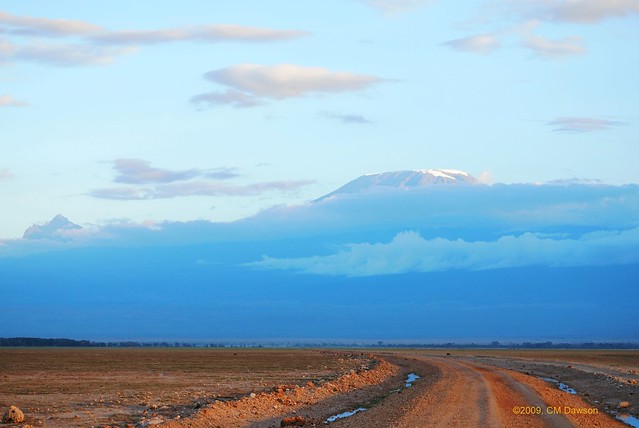
    Mount Kilimanjaro from the air
    Historical map with "Kilima-Ndscharo" in German East Africa, 1888
    Kilimanjaro, with its three volcanic cones, Kibo, Mawenzi, and Shira, is a dormant volcano in Kilimanjaro National Park, Tanzania and the highest mountain in Africa at 5,895 metres or 19,341 feet above sea level (the Uhuru Peak/Kibo Peak).[4]

    Contents

    [hide]

    [edit] Geology

    Kilimanjaro is composed of three distinct volcanic cones: Kibo 5,895 m (19,341 ft); Mawenzi 5,149 m (16,893 ft); and Shira 3,962 m (13,000 ft). Uhuru Peak is the highest summit on Kibo's crater rim.
    Kilimanjaro is a giant stratovolcano that began forming a million years ago, when lava spilled from the Rift Valley zone. Two of its three peaks, Mawenzi and Shira, are extinct while Kibo (the highest peak) is dormant and could erupt again. The last major eruption has been dated to 360,000 years ago, while the most recent activity was recorded just 200 years ago.
    Although it is dormant, Kibo has fumaroles that emit gas in the crater. Scientists concluded in 2003 that molten magma is just 400 m (1,310 ft) below the summit crater.[citation needed] Several collapses and landslides have occurred on Kibo in the past, one creating the area known as the Western Breach.

    [edit] Name

    It is unknown where the name Kilimanjaro originates, but a number of theories exist. European explorers had adopted the name by 1860 and reported that it was its Swahili name,[5] with Kilimanjaro breaking into Kilima (Swahili for "hill, little mountain") and Njaro,[6] whose supposed origin varies according to the theories—according to some it is an ancient Swahili word for white or for shining,[7] or for the non-Swahili origin, a word from the Kichagga language, the word jaro meaning "caravan". The problem with all these is that they cannot explain why the diminutive kilima is used instead of the proper word for mountain, mlima. The name might be a local joke, referring to the "little hill of the Njaro" being the biggest mountain on the African continent, since this is a nearby town, and guides recount that it is the Hill of the Njaro people. A different approach is to assume that it comes from the Kichagga kilmanare or kileajao meaning "which defeats the bird/leopard/caravan". However this theory cannot explain the fact that Kilimanjaro was never used in Kichagga before in Europe in the mid-19th century.[5]
    An alternative theory is as follows: On November 10, 1848, the German missionary Rebmann wrote in his diary, "This morning we discerned the Mountains of Jagga more distinctly than ever." Jagga was the pronunciation of Chagga by Europeans. Kilimanjaro may also be the European pronunciation of the Chagga phrase that "Kile-lema-irho", meaning "we failed to climb it" in Kiuru, Kioldimoshi, Kimarangu, Kivunjo, Kikibosho, Kimachame and Kirombo, Kichagga in general. If so, name itself, Kile-lema-irho/Kilimanjaro, would have been the Chagga way of explaining to kyasaka (newcomers) when they asked about the shining mountain top of Kibo and Mawenzi Peak. Kibo peak is more visible from the Kibosho Area, and Mawenzi from Maranu.[citation needed]
    The Ki- prefix in Swahili has several underlying meanings. The old Ka- diminutive noun prefix (found now only as Kadogo—a small degree), merged with the Ki class. One of its meanings was to also describe something unique of its kind: Kilima, a single peak, as opposed to Mlima, which would better describe a mountain range or undulating country. Several other mountains also bear this prefix, such as Kilima Mbogo (Buffalo Mountain), just north of Nairobi in Kenya. People with disabilities are also placed in this class, not so much as a diminutive idea; but a unique condition they possess: a blind or a deaf person, Kipofu and Kiziwi. This prefix "Ki-" in no way implies a derogatory sense. The name Kibo in Kichagga means "spotted" and refers to rocks seen on snowfields.
    In the 1880s, the mountain, at that time spelled Kilima-Ndscharo in German following the Swahili name components, became a part of German East Africa after Karl Peters had persuaded local chiefs to sign treaties (a common story that Queen Victoria gave the mountain to her grandson Kaiser Wilhelm II is not true).[8] When in 1889 Hans Meyer reached the highest summit on the crater ridge of Kibo, he named it "Kaiser-Wilhelm-Spitze" ("Kaiser Wilhelm peak").[5] That name was used until 1918, when after World War I the German colonies were handed over to the British empire. When Tanganyika gained its independence in 1961, this summit was named "Uhuru peak", meaning "Freedom peak" in Swahili.
    Peeking

    [edit] First ascent

    In 1861, the German officer Baron Carl Claus von der Decken and the young British geologist Richard Thornton (1838–1863) made a first attempt to climb Kibo,[9] but "got no farther than 8,200 feet"[10] (2,500 meters). In 1862, Von der Decken tried a second time together with Otto Kersten. They reached a height of 14,000 feet (4,280 meters).[11][12]
    In 1887, during his first attempt to climb Kilimanjaro, the German geology professor Hans Meyer reached the base of Kibo, but was forced to turn back, not having the equipment necessary to handle the deep snow and ice on Kibo. The following year, Meyer planned another attempt with cartographer Oscar Baumann, but the mission was aborted due to consequences of the Abushiri Revolt. Meyer and Baumann were captured and held hostage, and only escaped after a ten thousand rupees ransom had been paid.[13]
    In 1889 Meyer returned to Kilimanjaro with the celebrated Austrian mountaineer Ludwig Purtscheller for a third attempt. Their climbing team included two local headmen, nine porters, a cook, and a guide. The success of this attempt, which started on foot from Mombasa, was based on the establishment of many campsites with food supplies so that multiple attempts at the top could be made without having to descend too far. After Meyer and Purtscheller pushed to near the crater rim on October 3, exhausted from hacking footsteps in the icy slope, they reached the highest summit on the southern rim of the crater on Purtscheller's 40th birthday, October 6, 1889. They were the first to confirm that Kibo has a crater, which was filled with ice at the time. After descending to the saddle between Kibo and Mawenzi, Meyer and Purtscheller attempted to climb the more technically challenging Mawenzi next, but could only reach a 5096 m high subsidiary peak (later to be named Klute Peak) before retreating due to illness. On October 18 they reascended Kibo to enter and study the crater, cresting the rim at Hans Meyers Notch. In total, Meyer and Purtscheller spent 16 days above 4,200 m during their expedition.[13][14]
    The summit of Kibo wouldn't be climbed again until 20 years later (by the surveyor M. Lange in 1909), and the first ascent of the highest (5149 m) summit of Mawenzi was only on July 29, 1912, by the German climbers Edward Oehler and Fritz Klute, who christened it Hans Meyer Peak in Meyer's honor. Oehler and Klute went on to make the third ascent of Kibo, via the Western route over the Drygalski Glacier.[14]
    In 1989, the organizing committee of the 100-year celebration of the first ascent decided to award posthumous certificates to the African porter-guides who had accompanied Meyer and Purtscheller. One person in pictures or documents of the 1889 expedition was thought to match a living inhabitant of Marangu, Yohani Kinyala Lauwo. Lauwo did not know his own age nor did he remember Meyer or Purtscheller, but he remembered joining a Kilimanjaro expedition involving a Dutch doctor who lived near the mountain and not wearing shoes during the 8-day affair. Lauwo claimed that he had climbed the mountain 3 times before World War I. The committee concluded that he had been a member of Meyer's team and therefore must have been born around 1871.[15] Lauwo died on 10 May 1996 at the thus reconstructed world-record age of 124 or 125 and is now even often suggested as co-first-ascendant of Kilimanjaro.[16]

    [edit] Mapping

    Early maps of Kilimanjaro were published by the British Government's Directorate of Overseas Surveys (DOS 422 Y742) in 1963. These were based on air photography carried out as early as 1959 by the RAF. These were on a scale of 1:50,000 with contours at 100 ft intervals. These are now unavailable. Tourist mapping was first published by the Ordnance Survey in England in 1989 based on the original DOS mapping (1:100,000, 100 ft intervals, DOS 522). This is also no longer available. EWP produced a map with tourist information in 1990 (1:75,000, 100 m contour intervals, inset maps of Kibo and Mawenzi on 1:20,000 and 1:30,000 scales respectively and 50 m contour interval). In the last few years, numerous other maps have become available of various qualities.[3] 3D route maps are also available online.[17]

    [edit] Trekking Kilimanjaro

    There are six official trekking routes[18] by which to climb Mt Kilimanjaro, namely: Marangu, Rongai, Lemosho,[19] Shira, Umbwe and Machame. Of all the routes, Machame[20] is by far the most scenic albeit steeper route up the mountain, which can be done in six or seven days.[21] The Rongai is the easiest and least scenic of all camping routes with the most difficult summit night and the Marangu is also relatively easy, but accommodation is in shared huts with all other climbers. As a result, this route tends to be very busy, and ascent and descent routes are the same. [22]
    People who wish to trek to the summit of Kilimanjaro are advised to undertake appropriate research[23] and ensure that they are both properly equipped and physically capable. Though the climb is technically not as challenging as when climbing the high peaks of the Himalayas or Andes, the high elevation, low temperature, and occasional high winds make this a difficult and dangerous trek. Acclimatisation is essential, and even then most experienced trekkers suffer some degree of altitude sickness.[24] Kilimanjaro summit is well above the altitude at which high altitude pulmonary edema (HAPE), or high altitude cerebral edema (HACE) can occur.[25] All trekkers will suffer considerable discomfort, typically shortage of breath, hypothermia and headaches.
    High-altitude climbing clubs—citing safe ascent rate suggestions offered by organisations such as the Royal Geographical Society—have criticised the Tanzanian authorities for charging fees for each day spent on the mountain. It was once argued that this fee structure encouraged trekkers to climb rapidly to save time and money, while proper acclimatisation demands that delays are built in to any high climb. However, in response to this accusation, Tanzania National Parks Authority several years ago mandated minimum climb durations for each route. These regulations prohibit climbs of fewer than five days on the Marangu Route, and ensure a minimum of six days for the other five sanctioned routes. These minimums—particularly in the case of Marangu, which ostensibly allows that Uhuru Peak (5,895m) can be reached from a starting elevation at 1,860m within 72 hours of beginning the ascent—are reckoned by most alpinists to allow an ascent rate that will usually result in the climber failing to acclimatize adequately, by the time that Kibo Huts are reached; the launch base from which the summit is assaulted. Consequently, the incidence of Acute Mountain Sickness (AMS) is widely deemed to be unacceptably high on Kilimanjaro, with high volumes of fit young people succumbing to the condition, having opted for a relatively rapid ascent. As a general rule, it is far safer (and more enjoyable) to avoid altitude sickness by planning a sensible itinerary that allows for gradual acclimatisation to high elevation as one ascends. Operations that typically see in excess of a thousand climbers summitting annually and are best placed to identify such patterns, usually posit that an optimal climb length should last around seven to eight days.
    Tanzanian Medical Services around the mountain have expressed concern recently[when?] over the current influx of tourists that apparently perceive Kilimanjaro as an easy walk. However this is not the case. Many individuals require significant attention during their attempts, and many are forced to abandon the trek. An investigation into the matter concluded that tourists visiting Tanzania were often encouraged to join groups heading up the mountain without being made aware of the significant physical demands of the climb, although many outfitters and tour operators flaunt high success rates for reaching the summit. The Kilimanjaro National Park shows that only 41% of trekkers actually reach the Uhuru summit with the majority turning around at Gilman’s Point, 300 metres (980 feet) short of Uhuru, or Stella Point, 200 (660 feet) meters short of Uhuru. Kilimanjaro is often underestimated because it can be walked and is not a technical climb. However, many mountaineers consider Kilimanjaro very physically demanding.
    Some estimate that more people have died to date trekking up Kilimanjaro than Mount Everest but Everest is attempted by significantly fewer climbers.[citation needed] In August 2007 four trekkers died within a week underscoring the point that trekking to the summit should not be taken casually. Multiple people (trekkers, porters, and guides) die on the mountain each year. The majority of these deaths are porters, from hypothermia. Trekkers fall on steep portions of the mountain, and rock slides have killed trekkers. For this reason, the route via the Arrow Glacier was closed for several years. It re-opened in December 2007,[26] but the park officials advise against taking that route and tell trekkers that they can climb, but at their own risk. When attempting the Arrow Glacier route, trekkers must leave early in the morning and make it past the rock face before mid-afternoon as when the sun comes out, unfrozen rock slides become quite common.

    [edit] Unique vegetation

    Being an Afromontane sky island, Kilimanjaro has an enormous biodiversity while low in endemic species. However endemics include the giant groundsels in the bunchgrass tussock grasslands, and other flora adapted to living in alpine plant conditions.
    Kilimanjaro has a large variety of forest types over an altitudinal range of 3,000 m (9,843 ft) containing over 1,200 vascular plant species. Montane Ocotea forests occur on the wet southern slope. Cassipourea and Juniperus forests grow on the dry northern slope. Subalpine Erica forests at 4,100 m (13,451 ft) represent the highest elevation cloud forests in Africa. In contrast to this enormous biodiversity, the degree of endemism is low. However, forest relicts in the deepest valleys of the cultivated lower areas suggest that a rich forest flora inhabited Mt Kilimanjaro in the past, with restricted-range species otherwise only known from the Eastern Arc mountains. The low degree of endemism on Kilimanjaro may result from destruction of lower elevation forest rather than the relatively young age of the mountain.
    Another feature of the forests of Kilimanjaro is the absence of a bamboo zone, which occurs on all other tall mountains in East Africa with a similarly high rainfall. Sinarundinaria alpina stands are favoured by elephants and African Buffalos elsewhere. On Kilimanjaro these megaherbivores occur on the northern slopes, where it is too dry for a large bamboo zone to develop. They are excluded from the wet southern slope forests by topography and humans, who have cultivated the foothills for at least 2000  years.
    This interplay of biotic and abiotic factors could explain not only the lack of a bamboo zone on Kilimanjaro but also offers possible explanations for the patterns of diversity and endemism. If true, Kilimanjaro's forests would serve as a striking example of the large and long-lasting influence of both animals and humans on the African landscape.

    [edit] Physical features

    Mount Kilimanjaro as seen from Moshi town, Kilimanjaro region
    Kilimanjaro rises from its base, and approximately 5,100 m (16,732 ft) from the plains near Moshi. Kibo is capped by an almost symmetrical cone with scarps rising 180 to 200 m on the south side. These scarps define a 2.5 km wide caldera.[27] Within this caldera is an inner crater, the Reusch Crater. This inner crater was named after Dr. Richard Reusch. The name was conferred by the government of Tanganyika in 1954 at the same time it awarded Reusch a gold medal on having climbed Kilmanjaro for the 25th time. Reusch climbed Kilimanjaro 65 times and helped to establish the exact elevation of the crater.[28][29] Within the Reusche Crater lies the Ash Pit. The Reusche Crater itself is nearly surrounded by a 400 feet (120 m) high dune of volcanic ash.[30]
    Kilimanjaro is also notable for presenting the greatest area of the Earth's surface in one view. This is due to its height in combination with the surrounding flatness of the land.[citation needed]

    [edit] Ice

    In the late 1880s the summit of Kibo was completely covered by an ice cap with outlet glaciers cascading down the western and southern slopes, and, except for the inner cone, the entire caldera was buried. Glacier ice flowed also through the Western Breach.[31]
    An examination of ice cores taken from the North Ice Field Glacier indicates that the "snows of Kilimanjaro" (aka glaciers) have a basal age of 11,700 years.[32][33] A continuous ice cap covering approximately 400 square kilometers covered the mountain during the period of maximum glaciation, extending across the summits of Kibo and Mawenzi.[34] The glacial ice survived drought conditions during a three century period beginning ~2200 BCE.[35]
    The period from 1912 to present has witnessed the disappearance of more than 80% of the ice cover on Kilimanjaro. From 1912 to 1953 there was ~1% annual loss, while 1989–2007 saw ~2.5% annual loss. Of the ice cover still present in 2000, 26% had disappeared by 2007. While the current shrinking and thinning of Kilimanjaro's ice fields appears to be unique within its almost twelve millennium history, it is contemporaneous with widespread glacier retreat in mid-to-low latitudes across the globe. At the current rate, Kilimanjaro is expected to become ice-free some time between 2022 and 2033.[35]